
History of Tamborine Mountain
Tamborine Mountain was inhabited by Aborigines for tens of thousands of years and was the territory of the Wangerriburras. The Yugambeh language is the origin of the name Tamborine, which means wild lime and refers to the finger lime trees that grow on the mountain.
The Tamborine district was included in the Bunton Vale pastoral run (1843) which was renamed Tambourine. In time the name was applied to the parish and the plateau. In 1875 the first of several farm selections was taken up; the hilly terrain was considered inferior to the coastal flats, but it had excellent timber and deep soils. By 1886 most of the plateau was under selection, although not necessarily occupation. Mount Tamborine (the locality) was definitely occupied, with citrus and other orchards, vegetable crops and St Bernard’s Hotel. A village settlement, on farms much too small, started in 1888. A short-lived provisional school was opened in 1893.
North Tamborine was more easily accessible from the Logan Village railway station, and in 1898 a Brisbane family, the Geissmanns (Swiss and German) built Capo di Monte, serving as a residence and guest house. They succeeded in having a school opened in 1900 and a store was added to their guest house in 1909. The arrival of the Geissmanns coincided with a growing clientele of natural history holiday-makers, and Queensland Governors lent their patronage to the Capo. The first of several sections of the Tamborine National Park (and Queensland’s first), Witches Falls, was reserved in 1908.
Meanwhile Mount Tamborine children tramped daily to the Capo school, until a gradual growth in population satisfied the opening of a second school in 1914, named St Bernard. The increase in population mirrored a decrease in the acreages of rainforest timber
, as the Big Scrub was cut out and snigged down to saw mills. The supposed reserves of timber prompted the opening of a railway line from Logan Village, southwards across the plateau to Canungra. Opening in 1914-15, the line carried decreasing quantities as much of the best timber had been cut out, but it also did service with mixed freight and passengers. The line closed in 1955.
The Tamborine local government division (1893) had the unenviable task of maintaining local roads, and as late as 1930 tolled a road to stay financial. A splurge of land subdivisions during 1918-25 brought in rates, but also more traffic. The sub-dividers sold blocks to both permanents and weekenders, who incidentally provoked a building boom and kept Geissmanns’ sawmill (1911) going profitably. Guest houses were built to accommodate holiday makers. The Tamborine Progress Association agitated for road spending, the North Tamborine public hall (1923) and the Tamborine Show and memorial hall (1930) near Mount Tamborine. Farming included dairying and citrus (until the 1930s) and flower growing (freighted to Brisbane). Vegetable growing increased sharply to feed Allied servicemen during World War II, sparking a number of co-operative arrangements for farm machinery, transport and distribution.
Tamborine Mountain attracted a number of writers and artists, contributing to a local feeling for the preservation of natural landscape. At various intervals from the 1920s to the 1960s, lands were donated and reserved for national parks. Notable examples were Palm Grove on the eastern escarpment (1925), the Knoll (1954) and Franklin (1957), which contains a Lepidozamia cycad reserve. The reserves contributed immeasurably to Tamborine Mountain’s tourist appeal, made more accessible by a road from the Gold Coast (1958, officially opened 1966). A country club golf course and several residential estates were promoted during 1958-60s.
The Tamborine Mountain Road (1922-25) linked North Tamborine to the Tamborine railway station, serving both local farmers and tourists. A short section, known as Geissmann Drive, passes through a national park, and it is listed on the Queensland heritage register.
Dairying tailed off in the 1950s, and avocado farming increased sharply. Proximity to the Gold Coast provoked a proposal for a theme park in 1979, replete with a fiberglass avocado and miniature train. Local residents opposed the scheme, in keeping with their willingness to do without reticulated water and sewerage. As a consequence, the mountain’s landscape has been less severely touched by building activity, maintaining the mountain’s tourist appeal.
Tamborine Mountain’s population history:
Tamborine Mountain’s census population in 2006 was 6534. The median age of its residents was 46 years, compared with 37 for Australia.
A selector, Cornelius Brady, was the first to take up farm land at Eagle Heights (1879), but the nearest place of settlement was North Tamborine, immediately to the west. After 1918 there was considerable land subdivision on the plateau – the railway had opened in 1918 – and the Eagle Heights subdivision began in the early 1920s. Buyers were weekend visitors and a few permanents. A post office receiving point was opened in 1926, and the spacious Eagle Heights Hotel was opened. A two-storey, Tudor design building, the hotel burnt down in 1964.
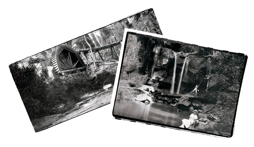
In 1932 a resident, Jessie McDonald, donated land for conservation purposes. Situated in Wongawallan Road, the McDonald Reserve was later enlarged and is one of the numerous parts of the Tamborine National Park. A botanic garden adjoins it. There are several points around Eagle Heights with views over the Gold Coast or back to the McPherson Range. In between are rainforest walks and waterfalls.
Eagle Heights experienced moderate growth in the postwar years and sudden spurts in the 1980s-90s. The main approach, Long Road, is a strip shopping centre for antiques, galleries and eateries. As the Tamborine Plateau’s largest population centre Eagle Heights has the local library and main shopping area. Churches, schools and halls are in or close to the older settlements of North Tamborine and Tamborine Mountain. The old church (c1882), among the oldest buildings on the plateau, is in the galleries strip but erected there after transfer from Nerang.
In 1997 Eagle Heights was designated a locality within the larger district of Tamborine Mountain which also included North Tamborine and Mount Tamborine
| Census Date | Population |
| 1911 | 1188 |
| 1933 | 2674 |
| 1947 | 2596 |
| 2006 | 6534 |
| 2016 | 7056 |
.